Satellite Data and GIS help Ghana Improve Returns on its Infrastructure
Satellite Data and GIS help Ghana Improve Returns on its Infrastructure
12 June 2014 | by Vineeta Shetty
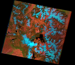
In common with many emerging countries, Ghana faces a problem in the way public sector agencies manage existing infrastructure assets. Two years ago, with a view to update management practices and to plan for long-term infrastructure needs, the Ghanaian National Development Planning Commission (NDPC) and Ministry of Finance and Economic Planning (MOFEP) teamed up to prepare a National Infrastructure Plan.Improving the socio-economic returns on its infrastructure was the key objective of the Plan but the principal challenge before the two agencies was the inventory and analysis of the nation’s dispersed assets, including water and sanitation, habitation, energy, transportation, health and education. Land use datasets generated from high-resolution Landsat 7 images document and analyse the current state of land use across the country.The Center for Remote Sensing and Geographic Information Services (CERSGIS) at the University of Ghana in Legon, stepped in with a big data solution, designing and deploying web-based database applications tailored to the task. The apps were linked to visualization tools for mapping the spatial distribution of natural resources identified and prioritized by the government agencies.
Geographic Information Systems (GIS) allow creation, visualization, querying and analysis of spatial data and can range in complexity from “off-the-shelf” desktop software to a networked system of sensors, national databases and workstations, such as those at CERSGIS’ campus.
While spatial data is available to a limited extent through maps and survey statistics, geo-referenced data gathered by satellite imagery is becoming crucial in African countries to understand, plan and manage land, riverine and atmospheric resources in countries where data cannot be collected or processed manually because of impenetrable geographies or available manpower.
Data that pinpoints the geographic location of features and boundaries such as natural or man-made features, rivers and so on, can be captured and stored as coordinates and topology. They can be accessed, manipulated and analyzed through tools such as tables and lists, maps and 3D virtual models and become invaluable for land use planning, forest management, soil erosion, weather forecasting and so on.
Not only do satellite images reduce time and effort that would have been spent manually searching records, but visual information is more compelling than tables and numbers to convince policy-makers and funders and is easier to update and disseminate.
In the case of Ghana, land use datasets were generated from high-resolution Landsat 7 images to document and analyse the current state of land use across the country. Rainfall, presence of primary or secondary roads, major towns, market towns, for example, also feed into the suitability analysis. The outcome is a detailed display of the most suitable to least suitable areas for restoration, while filtering out unuseable or less desirable sites.
The solution developed by CERGIS was two years in development and delivered this year as a monitoring and evaluation tool for the key stakeholders. The web-based National Infrastructure Planning Portal allows a view of the nation’s assets at a glance and facilitates regular update and retrieval of information by specific geographic locations.
Through the use of radar remote sensing, which penetrates clouds and vegetation, CERSGIS was able to indicate the extent to which current human activities were affecting the nature and use of land in Ghana and help make relevant projections and review policies to preserve the land for its intended use.
Satellite Data and GIS help Ghana Improve Returns on its Infrastructure